Small Woodland Owners' Group

Old maps

Recommended reading, web sites, resources

Re: Old maps

Postby Landpikey » Fri Jan 18, 2013 9:17 pm

Dredger99

Try this;
http://maps.nls.uk/os/6inch/view/?sid=7 ... &layers=BT

Let me know how it goes!

Cheers
Dave
Landpikey
 
Posts: 58
Joined: Mon Dec 17, 2012 7:12 am

Re: Old maps

Postby dredger99 » Sun Mar 31, 2013 9:15 pm

Sorry for the delay on getting back to you.
Thats perfect thanks.
dredger99
 
Posts: 35
Joined: Sat Jul 07, 2012 8:33 pm

Re: Old maps

Postby TerryH » Tue Feb 25, 2014 5:41 pm

Thanks. This ( http://www.old-maps.co.uk/maps.html ) was very interesting. I didn't realize until I saw these maps that our wood (or rather the road that it is adjacent to) is actually on the Surrey/Sussex border itself... thought we were a few miles inside Sussex. So I can do the old ... steps to the left "Now I'm in Surrey", steps to the right "Now I'm in Sussex", steps to the left.. gets hit by a car... trick!
The maps go back to 1875 for our wood and show the seasonal stream that is still present to this day. Back then the big field to the east of us was four smaller fields separated by corridors of trees. One of these corridors joined into our wood (no sign of it now though ). The larger forest to our south was a bit smaller then too; some of it was fields.

Stayed this way until some time between 1968 and 74 when the four fields become one and the fields in the main forest got planted with trees. Perhaps some 'give and take' was the thinking; plant new trees because they had to cut down some ancient trees.

Anyway, useful... thanks
TerryH
 
Posts: 65
Joined: Sun Jan 05, 2014 3:23 pm
Location: Surrey/West Sussex

Re: Old maps

Postby oldclaypaws » Wed Feb 26, 2014 3:26 pm

This is my wood in 1750. Note the pond by the road, basically a big hole where they'd been digging clay, and the curious 'depressions' in the middle, where more shallow clay pits had been dug- this area is about 2-3 ft lower than the surrounding fields.

1750 Map.jpg
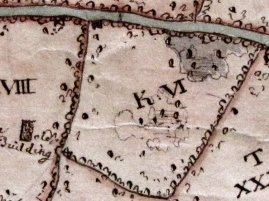
1750 Map.jpg (20.1 KiB) Viewed 20483 times


There are several individual trees shown in the wood, presumably the big ones they'd worked round, as my oldest oaks which are still there date from around 1600. Theres a clay 'puddling pit' still in the corner of the wood today, close to the building in the adjacent field. Both the wood and field + building were owned by a family of well known potters.

15 years later, the wood is shown as totally covered by trees, so maybe the earlier 1750 map showed it when it had been clear coppiced for fuel and to get access to the clay.

1765 Map.jpg
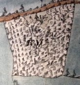
1765 Map.jpg (12.18 KiB) Viewed 20483 times


Unfortunately thats the earliest maps, but the features suggest its been there for many centuries; the holloway road is up to 6 ft below the surrounding fields, worn down by carts and hooves over the centuries.

Here we are now by satellite and google maps, the accuracy of the 18th Century maps is comparatively impressive and the shape is exactly the same. You can also still see the smaller trees covering the site of the (filled in) pond

2012 google.jpg


We've got the full documented history of the manor during the medieval period back to the 8th Century, so get a real sense of history under our feet. I'm the eighth owner in the last 1400 years. Don't think Henry VIII did much hedge laying or coppicing in the wood though, lazy sod was too busy jousting, writing 'Greensleeves' and chasing skirt.
oldclaypaws
 
Posts: 1132
Joined: Mon Sep 02, 2013 5:13 pm

Re: Old maps

Postby Meadowcopse » Sat Mar 01, 2014 10:48 am

Oldclaypaws:
busy jousting, writing 'Greensleeves' and chasing skirt.

That used to be a typical Saturday afternoon for me :)

Chancery Deeds are a handy resource:
http://www.british-history.ac.uk/catalogue.aspx?gid=119

The 'C' series seems to have a lot of local stuff for my area:
http://www.british-history.ac.uk/report.aspx?compid=64493

Sometimes you have to spell the name of a village in the search box in the style it would have been in old documents (and allow for the same village name cropping up in a few places across England).
Meadowcopse
 
Posts: 207
Joined: Sun Jul 04, 2010 7:13 am
Location: Cheshire

Re: Old maps

Postby TerryH » Sun Mar 02, 2014 8:56 pm

Those Chancery Deeds are a great source of information.

( What follows is probably of no interest to anyone other than myself, but anyway.... )
Our tiny little plot was once part of a 800(?) acre estate called the "Nunnery Estate" which goes back to 1380, and earlier. As the name suggests, the estate grew out from a priory (built circa 1200) of Benedictine nuns. Then, along came that skirt-chasing jouster and the estate went to the Crown in 1537. Since this time the estate seems to have been sold/changed families about nine times. However the Chancery Deeds go into great detail about the estate passing down the line within families, including the "Stone" family where it passed through five heirs who were all very imaginatively called John ! Over time, the High Sheriff of Sussex has held the estate as have various "Sirs" and "Colonels". The last family to hold the entire estate began to sell off small parts of it to local farmers/ 'normal' people in the 1990's and one of those then split off our little 4 acre woodland as they had no use for it presumably.

It's nice to be able to trace it's history of 800 years from such illustrious families down to a grubby little peasant like me !!
TerryH
 
Posts: 65
Joined: Sun Jan 05, 2014 3:23 pm
Location: Surrey/West Sussex

Re: Old maps

Postby Meadowcopse » Sun Mar 02, 2014 9:52 pm

National Archives are really handy and rather interesting.
Although not particularly of land holding interest - The Chester Cathedral Consistory Court - containing a fascinatingly detailed element of everyday disputes makes the Jeremy Kyle Show look tame...
Had great fun showing my ageing rural father his various ancestors indiscretions and public arguments, and due to people not really travelling far in the late 1500s, the various neighbours involved in controversial accusations of horizontal liaisons ultimately become related at some point anyway...

from 1560: "TILSTON John Fytton wife of Robert Fytton c Ralph Leche for saying to Joan "Thou art a nawghty harlot with other similar words" which were spoken in the Town fylde of Cardesey - libel."

http://www.nationalarchives.gov.uk/a2a/records.aspx?cat=017-edcall&cid=0#0
Meadowcopse
 
Posts: 207
Joined: Sun Jul 04, 2010 7:13 am
Location: Cheshire

Previous

Return to Woodland Owners Wish List

Who is online

Users browsing this forum: No registered users and 1 guest

cron