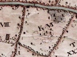
This is my wood in 1750. Note the pond by the road, basically a big hole where they'd been digging clay, and the curious 'depressions' in the middle, where more shallow clay pits had been dug- this area is about 2-3 ft lower than the surrounding fields.

- 1750 Map.jpg (20.1 KiB) Viewed 20483 times
There are several individual trees shown in the wood, presumably the big ones they'd worked round, as my oldest oaks which are still there date from around 1600. Theres a clay 'puddling pit' still in the corner of the wood today, close to the building in the adjacent field. Both the wood and field + building were owned by a family of well known potters.
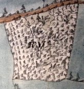
15 years later, the wood is shown as totally covered by trees, so maybe the earlier 1750 map showed it when it had been clear coppiced for fuel and to get access to the clay.

- 1765 Map.jpg (12.18 KiB) Viewed 20483 times
Unfortunately thats the earliest maps, but the features suggest its been there for many centuries; the holloway road is up to 6 ft below the surrounding fields, worn down by carts and hooves over the centuries.
Here we are now by satellite and google maps, the accuracy of the 18th Century maps is comparatively impressive and the shape is exactly the same. You can also still see the smaller trees covering the site of the (filled in) pond
We've got the full documented history of the manor during the medieval period back to the 8th Century, so get a real sense of history under our feet. I'm the eighth owner in the last 1400 years. Don't think Henry VIII did much hedge laying or coppicing in the wood though, lazy sod was too busy jousting, writing 'Greensleeves' and chasing skirt.
